The Collect Earth Online team has been busy introducing new features and addressing bugs. In 2024, CEO saw numerous updates, both major and minor, to project creation, the collection page, and data export options. Read on for more information and a sneak peek at our next major feature for 2025!
We’ve added multiple user requested quality of life improvements to CEO’s project creation process.
One hotly anticipated feature is the ability to import Collect Earth projects into Collect Earth Online. Collect Earth projects stored as .cep files can be used. A “How-to” blog post about this exciting new feature will be coming shortly!
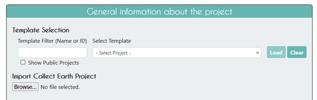
Administrators can now also specify their plots and samples by uploading GeoJSON files. This feature works very similarly to the existing ability to specify plots and samples by uploading .shp (SHP) files. GeoJSON files are widely used by web mapping applications including Google Earth Engine.
Finally, project administrators can now add learning materials to each project. When learning material is added to the Project, users will be able to access this information from the data collection page. A “How-to” blog post is available to help unlock the potential of this informative new feature!
On the backend, we’ve improved validation processes for project creation and added alerts when creating plots from files.
We’ve added multiple features to the data collection page to make it easier for users to collect data. These features also make reviewing the data collected easier and help increase data quality.
On the collection page under Imagery Options, you’ll now see an option to “Enable Map Grid”.
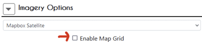
Enabling this option will overlay a grid that changes size depending on the level of zoom.
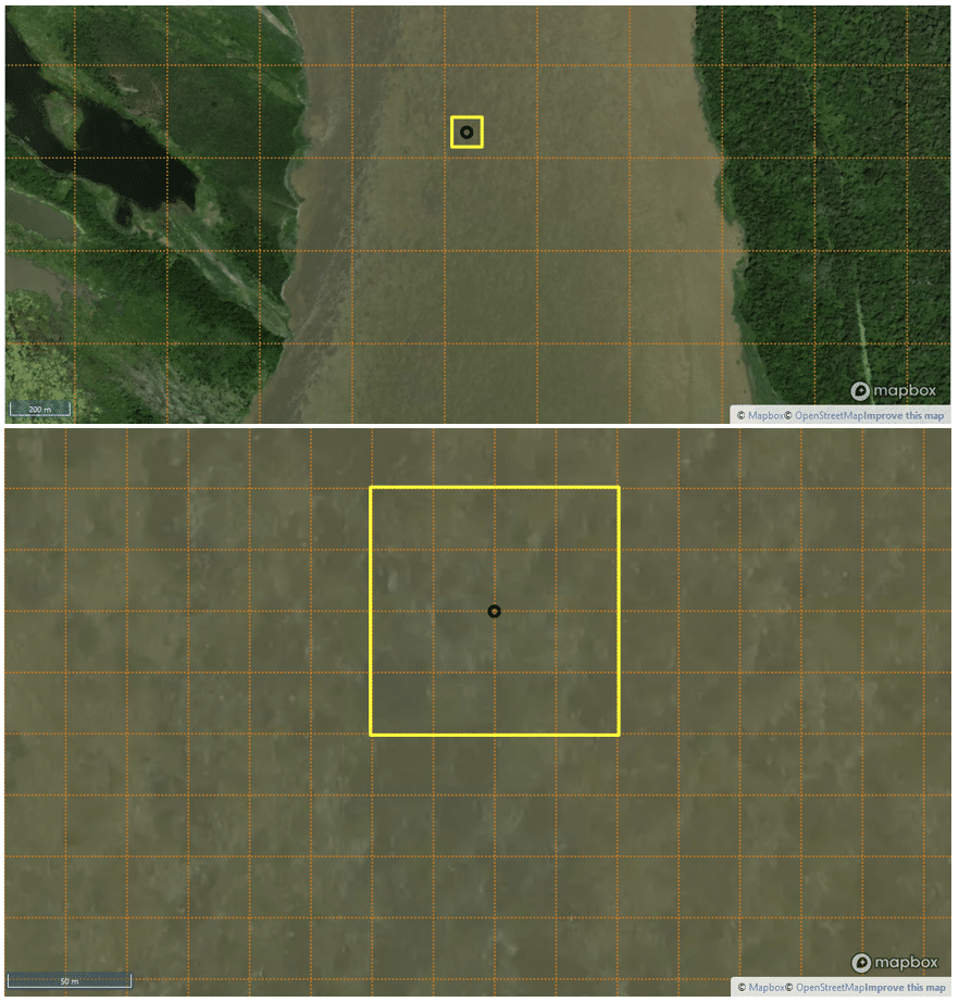
This grid function can help data collectors estimate things like percent land cover for plots and samples.
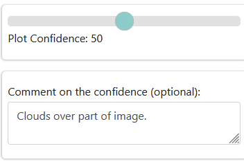
Another new function is the addition of a confidence comment section that appears when the confidence slider is present for the project. Data collectors can use this field to add comments about why they felt confident or not about a plot.
We’ve also added date navigation buttons for Planet NICFI imagery and Geo-Dash widgets.
Finally, we’ve added the ability to sort additional data for plots, and users can now select plots from the map in the main collection page for projects created using CSV, SHP, and geoJSON files.
Data export is also now easier for administrators. We’ve added a new field (visible_id) for samples when exporting shapefiles. Plot and sample CSV exports now contain project questions in the same order as they appear in the data collection page, and users can create user-defined column names (column headers) when exporting questions and answers.
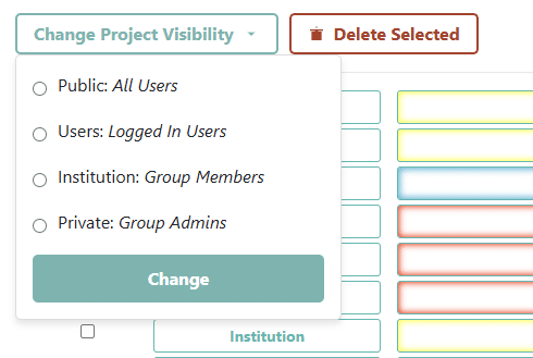
In addition, there are now bulk actions for data export and other institution management actions.
For project management, multiple projects can be selected. The administrator can then change the project visibility or delete the selected projects. This allows administrators to, for example, release multiple projects to a group of data collectors at the beginning of a data collection event.
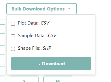
Administrators can also bulk download data from projects.
Finally, we’ve quashed some bugs, including:
In the works is a new QAQC Module, which will provide enhanced information about projects, plots, and users to administrators. It will also allow administrators to integrate outside sources of data to compare with user collected data, such as land cover model outputs or previous year’s data! Watch here for more information.
CEO would like to thank its ongoing funders. Thanks also to CEO’s technology partners: Norway’s International Climate & Forests Initiative for funding open high-resolution data availability; Planet for providing high-resolution imagery; and the Google Earth Engine team for creating a platform for Earth science data and analysis.
Collect Earth Online is working constantly to improve the user experience, and your feedback is invaluable. If you have ideas to share, please write to support@collect.earth.
Thank you!