High-resolution Planet imagery from Norway’s International Climate and Forest Initiative (NICFI) will no longer be accessible on CEO or other platforms starting April 1, 2025. This is because the current phase of NICFI’s program to provide high-resolution Planet imagery for free, which partnered with Planet and Kongsberg Satellite Services (KSAT), has ended.
As of April 1, 2025, both the historic and current imagery from the Planet NICFI program will no longer be available or viewable in Collect Earth Online. This applies to both existing and new projects.
NICFI is currently developing a new phase of the Satellite Data Program, to be launched later this year. CEO will investigate the possibility of adding new satellite imagery to the platform after NICFI launches the new phase of the Satellite Data Program.
Planet has also recently launched the Tropical Forest Observatory (TFO) to improve tropical forest monitoring. This subscription service includes all of the same imagery as the previous Planet NICFI offering and will continue to be updated at a monthly cadence. The basemaps include bi-annual PlanetScope Visual and Surface Reflectance Basemaps over natural lands from December 2015 through August 2020 and Monthly PlanetScope Visual and Surface Reflectance Basemaps from September 2020 onwards.
After subscribing to the TFO, Collect Earth Online users can use Planet’s Tile Services to connect TFO with CEO.
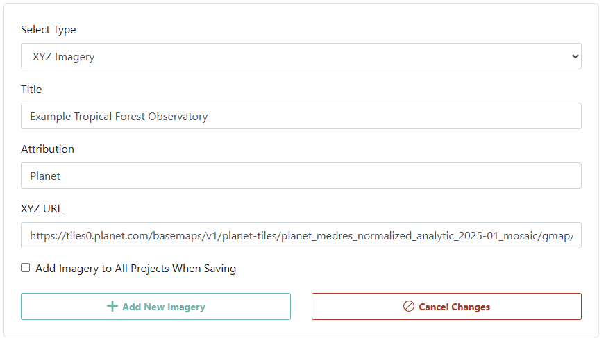
An example for adding XYZ imagery for January, 2025 is below.

Note that due to how the Planet API works, you will not be able to switch between available time periods with the TFO product. You will need to set up one imagery per time period of interest. Here, the XYZ URL is:
https://tiles0.planet.com/basemaps/v1/planet-tiles/planet_medres_normalized_analytic_2025-01_mosaic/gmap/{z}/{x}/{y}.png?api_key={api-key}.
Collect Earth Online will continue to provide other satellite imagery, including MapBox satellite, Sentinel 2, and Landsat imagery.
To read more about how to add these and other basemap imagery to your Institution for use in your projects, please see the documentation here.
We understand that this imagery is an important resource for crucial programs, and we are actively exploring solutions. Please email support@collect.earth if you have additional questions.